Infrastructures of Power: Caguas and Dorado, Case Studies in Disaster Capitalism
While Hurricane Maria was undoubtedly powerful, making landfall in Puerto Rico with 155 mph winds as a Category 4, bringing nearly 40 inches of rainfall, and causing over 40,000 documented landslides; the slow recovery in the storm’s wake is arguably due to much more than Maria’s sheer strength. The hurricane struck an island already crippled by debt, in the midst of a housing crisis with record vacancy rates, and served by outdated and inefficient infrastructural systems such as energy and water. These issues, while exacerbated, were certainly not caused by the storm itself, but have rather been brought to light on account of it. One of the primary issues facing recovery was how to rebuild in a broken system entangled with colonial histories and corrupt governments. The other, who, or by what metrics, decides.
A well-known demonstration of this infrastructural failure during recovery was created using NASA’s Black Marble data by a team at the Goddard Space Flight Center. A series of images displays Puerto Rico’s night sky as a factor of luminosity; first, a baseline, then, immediately following Hurricane Maria, then through the following months during the island’s slow restoration of power. The published data was last collected March 20, 2018. On this day, The Department of Energy reported that 92% of its customers had been restored power; The Federal Communications Commission reported that 95% of cell sites were operable; and PREPA reported that 99% of peak load on the island, 95% of customers, and 100% of municipalities had been restored power. These numbers imply that infrastructural, and even consumer, energy consumption was near equivalent to consumption levels pre-Hurricane Maria. If this were the case, the latest visualization from NASA’s project should appear near-identical to the island’s baseline visualization - but it does not.
Source: NASA Goddard Space Flight Center
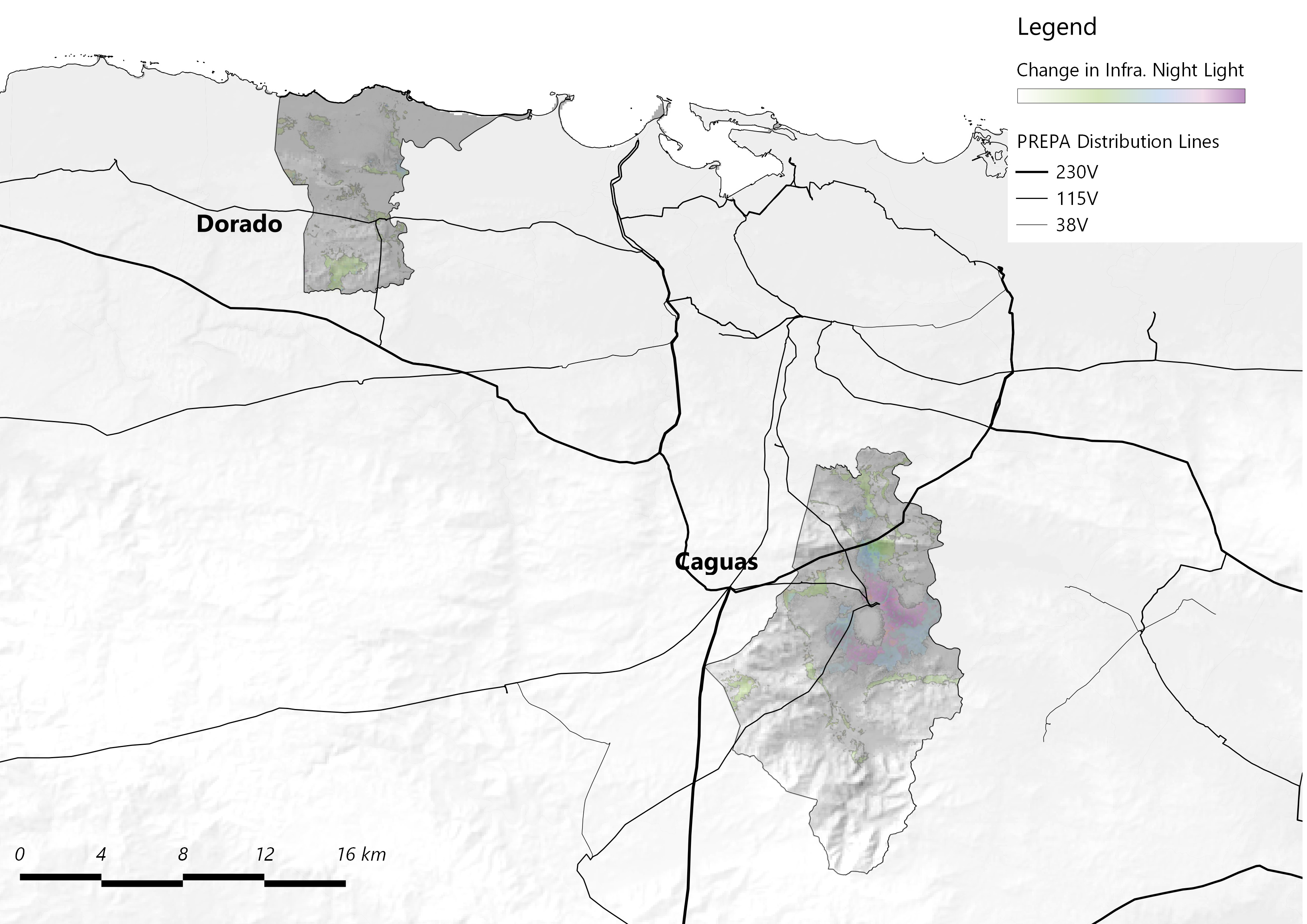
We conducted a pixel-level color delta analysis to visualize a new metric: change in infrastructural energy consumption pre- and post-Hurricane Maria. This analysis reveals not only areas with or without power, but highlights the regions which were disproportionately placed back onto PREPA’s grid, the last 0-8% yet attended to by national agencies.
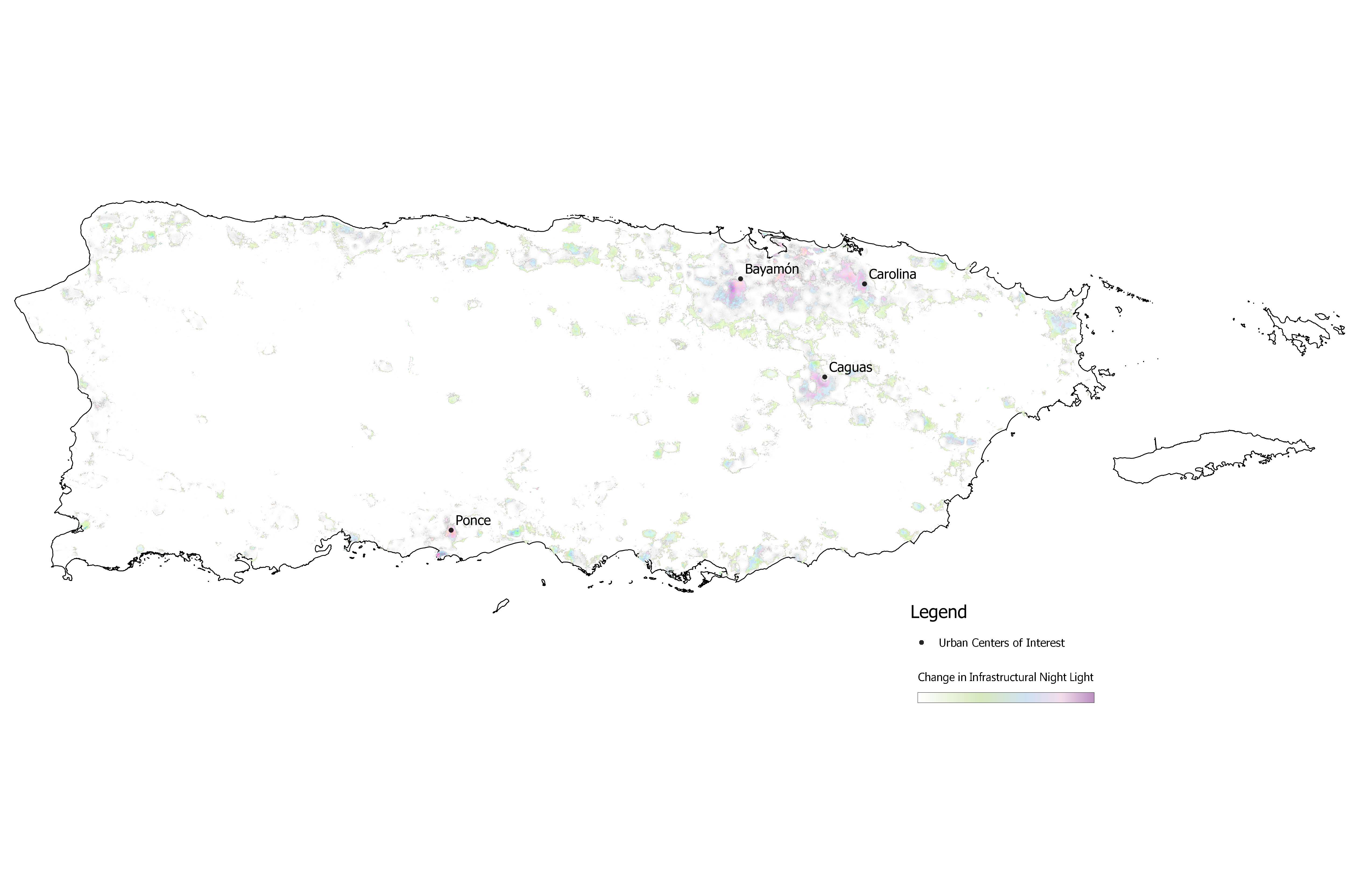
Expecting these to be primarily rural, southern, or mountainous, we were surprised to learn that the four highlighted regions were all urban, across different geographical conditions, and only one on the southern half of the main island: Bayamón, Caguas, Carolina, and Ponce. Why were these urban, populated municipalities those most neglected during infrastructural recovery? By what other metrics is this disproportionate aid made visible or explained?
Further inquiry into these questions revealed a second, in some ways more surprising, discovery. While it follows that these municipalities were those which have seen some of the most significant drops in property values between 2016-2018 (a timespan which brackets, and near-isolates effects to Hurricane Maria and its fallout), between $6,000 and $22,000 on average; three municipalities showed astronomical increases in property values within the same two years, from $65,000 to $80,000 on average. These being the islands of Vieques and Culebra, and the mainland municipality of Dorado.
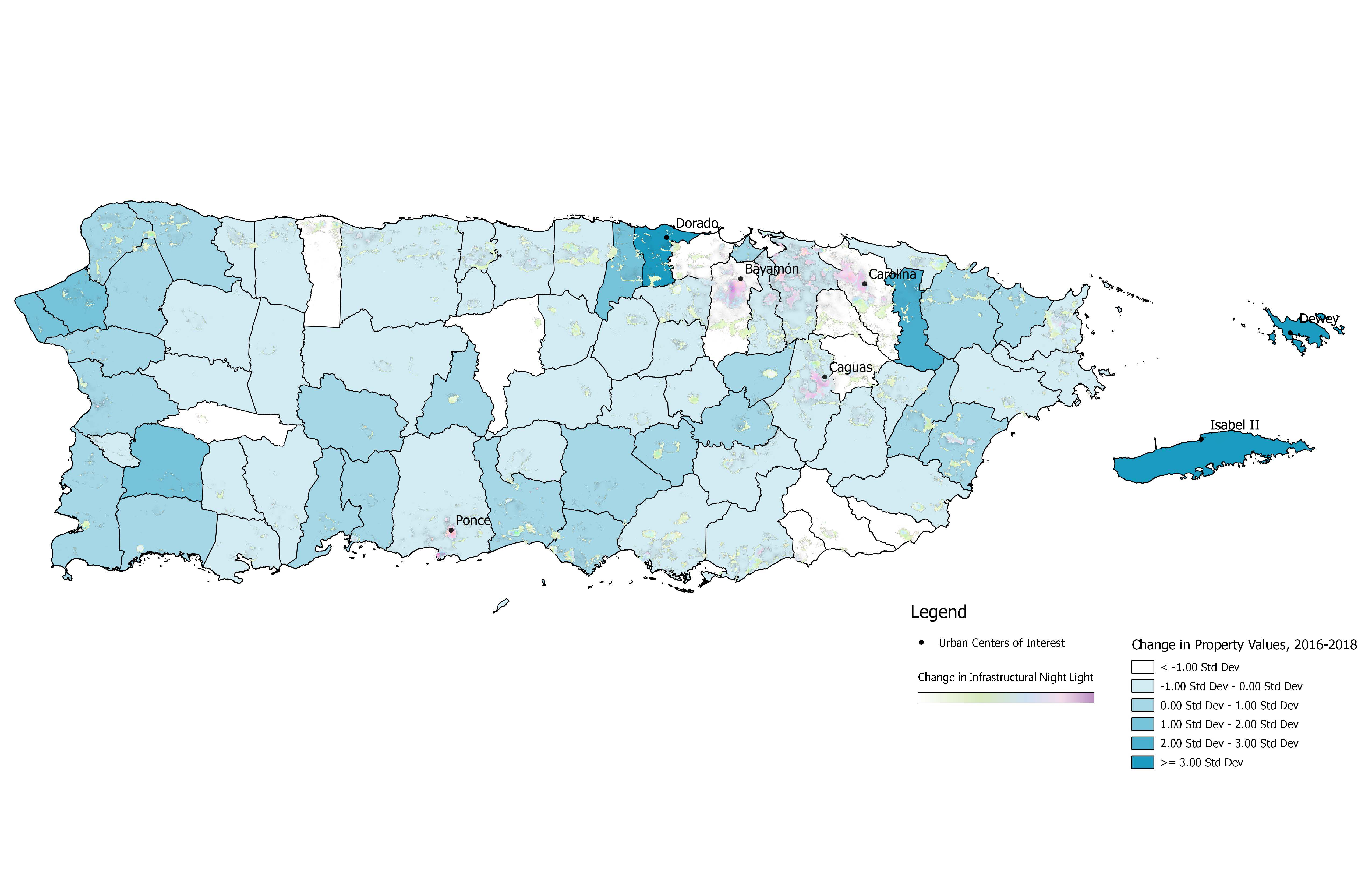
We then faced the opposite questions: Why were these municipalities, largely rural, none of which directly supported by PREPA’s main distribution lines, financially benefiting so greatly in the recovery following Hurricane Maria? How are they different from Bayamón, Caguas, Carolina, or Ponce?
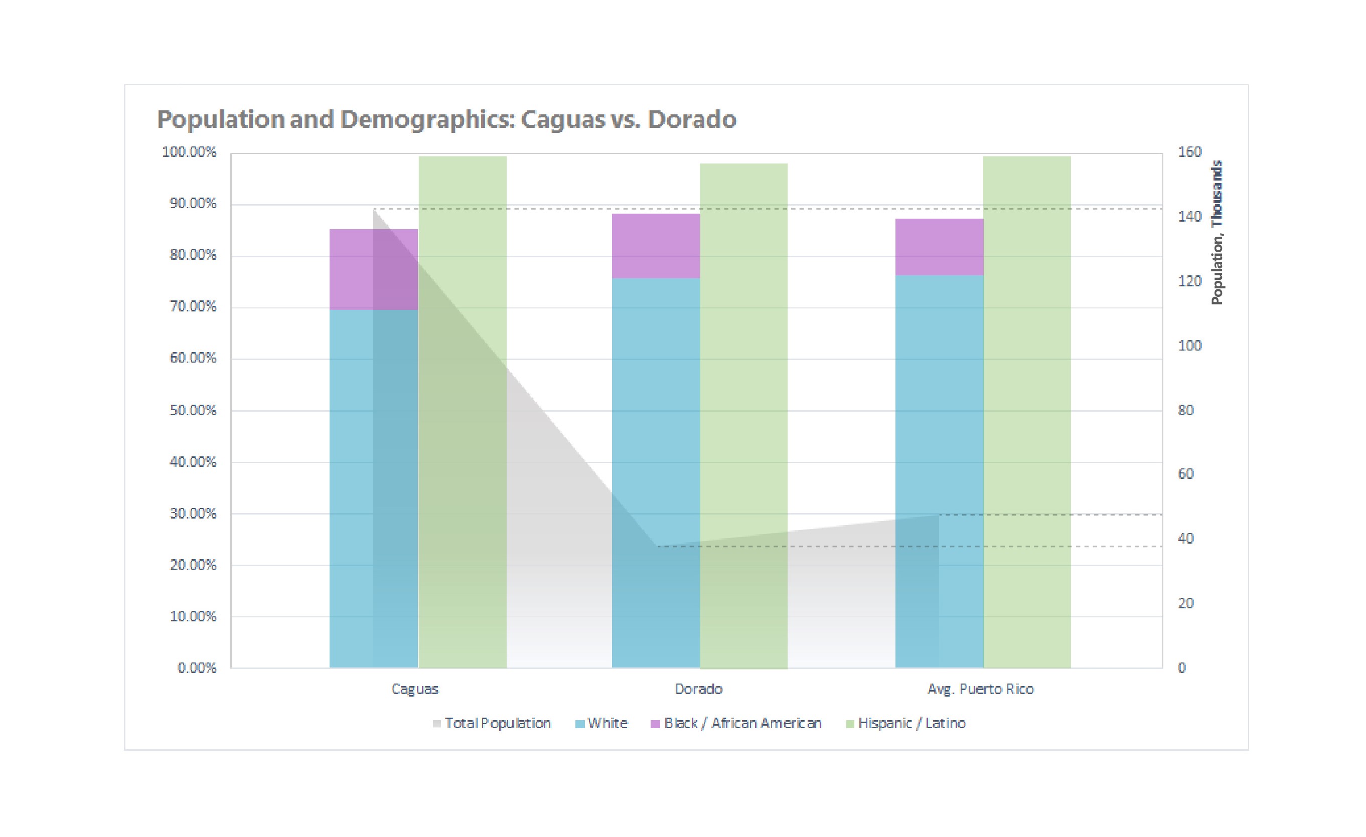
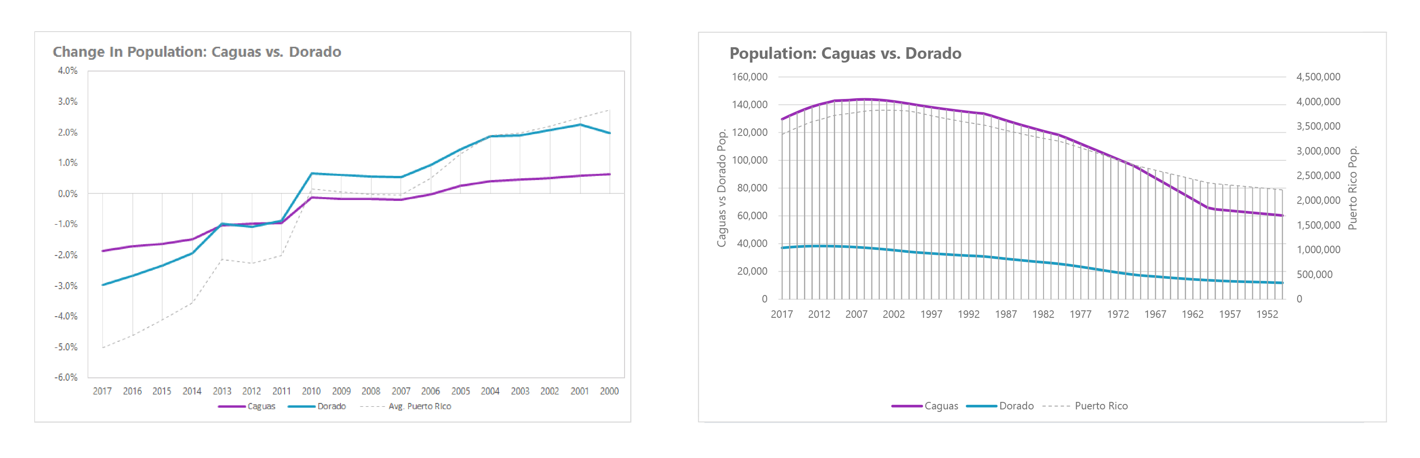
What follows are the results of two case studies comparing the geographies, climate, infrastructure, and more between Caguas and Dorado, each a municipality disproportionately affected, one negatively, one positively. These two municipalities were chosen because of their similarity in land use, which might suggest similar planning intentions, their relative distance to San Juan, which suggests similar access to resources, their similar demographic makeup as determined by the 2010 Census, as well as their availability of data.
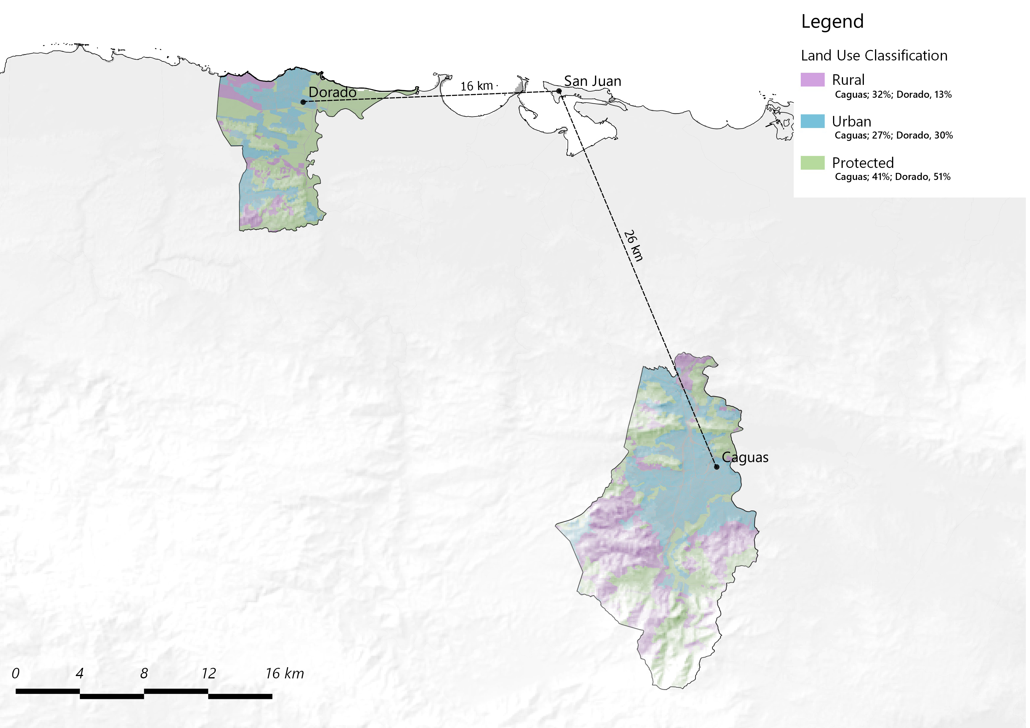
Caguas is in the Central Mountain Range of Puerto Rico’s mainland, the largest of the island’s valleys. It is entirely landlocked, and although a main distribution line runs just adjacent, and parallel, to Caguas, it relies on PREPA’s secondary grid for energy, bypassed by more reliable power. Transportation within and around Caguas is extremely limited. The municipality has only one freeway, one tolled expressway, and one divided highway. While these roads provide access to the north, south, and east, there is practically no route to the west. Historically, Caguas was a municipality important in Puerto Rico’s export of sugarcane to the United States, having an agrarian economy which tied population and social resources to harvest production.
Dorado, by contrast, is a northern, coastal municipality. It is also serviced by secondary distribution lines, but, unlike Caguas, is not along a primary line. Like Caguas, road transportation is limited; here giving access to only the east and west, but not south. However, from 1942 to 1996 Dorado had its own airport for propeller planes, which primarily serviced private and chartered American planes. The municipality has a very different history than Caguas. While some limestone quarries exist, the region was never a primary source of natural exports. Instead, Dorado’s economy was focused on tourism in the early 20th century after the Rockefeller family bought land, and moved into pharmaceutical manufacturing after the creation of Section 936 Tax Code of 1976. Boston Scientific, Pfizer, Nextgen, and Heraeus have all operated out of Dorado.
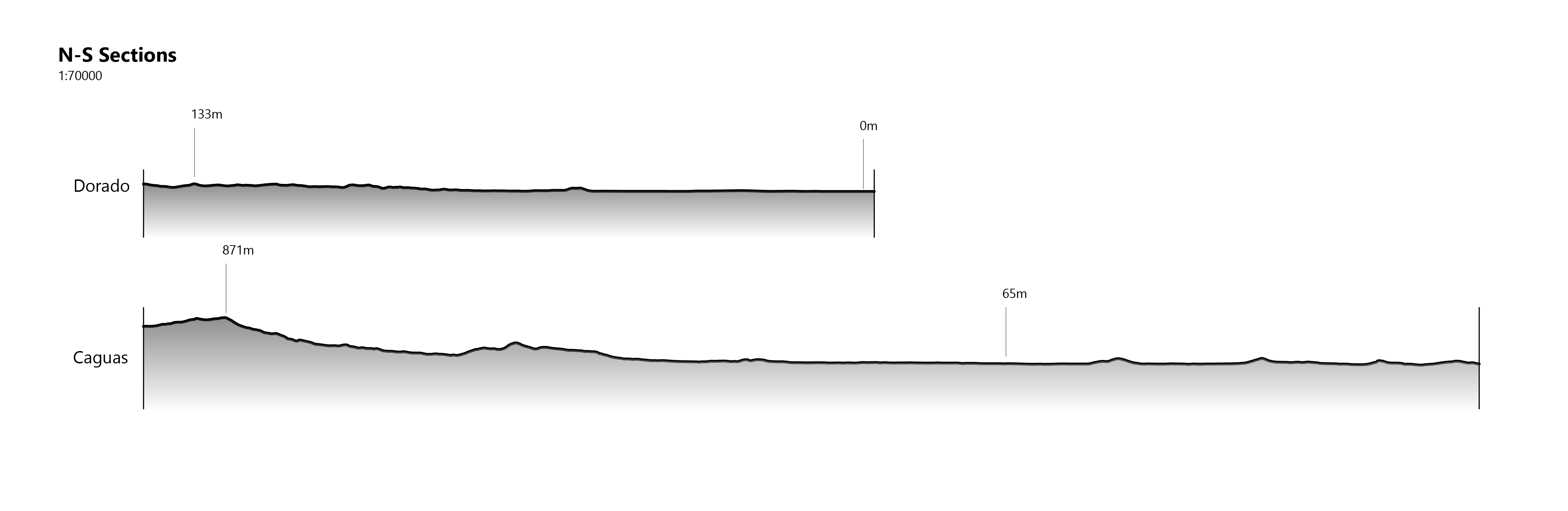
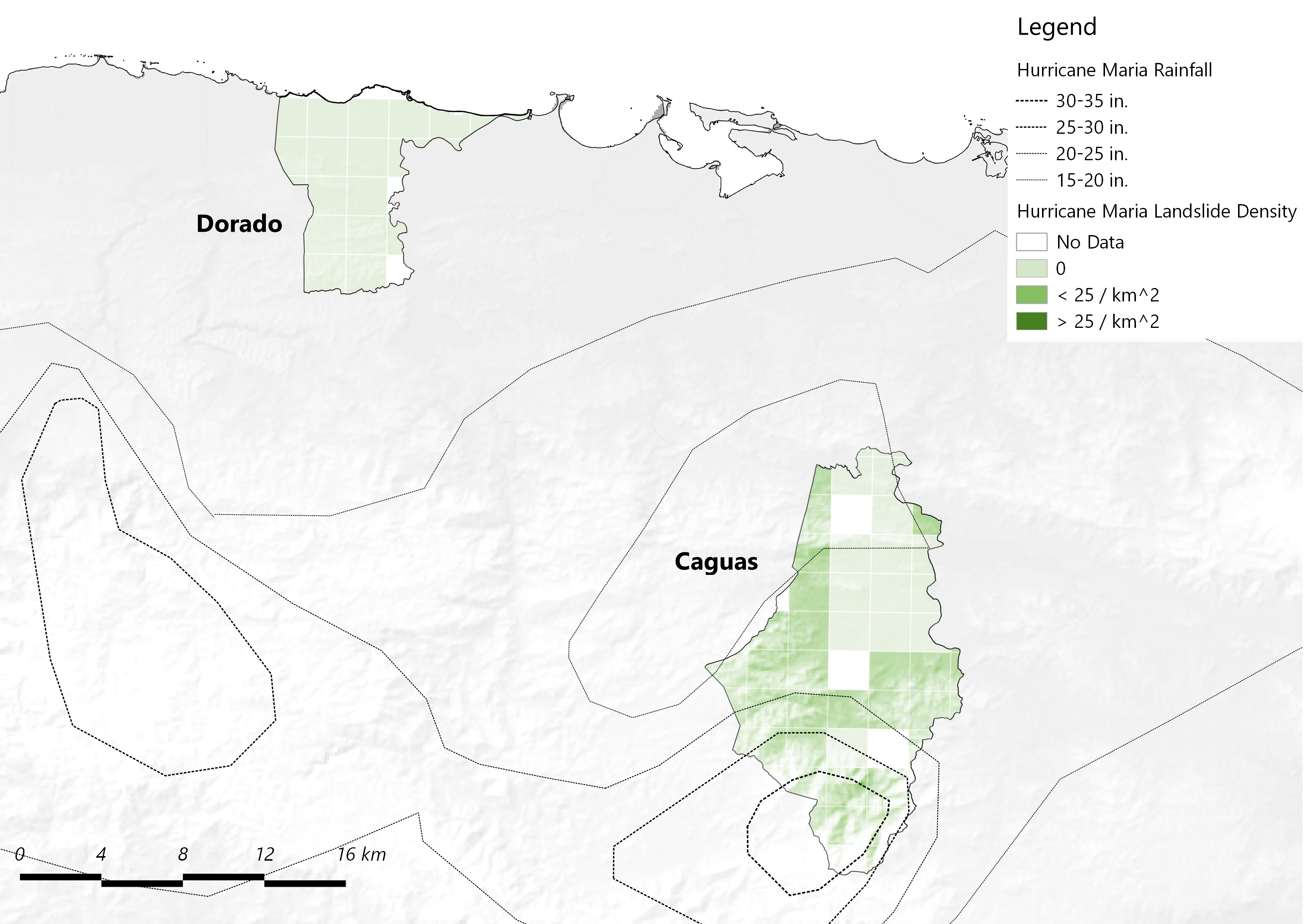
Geographically and environmentally, the two municipalities are drastically different. Caguas, situated within a mountain valley near the island’s rainforest, experiences elevation changes over 800 meters within its 153 square kilometers, These factors make it particularly susceptible to flooding, soil inundation, and landslides - all of which were recorded during and after Hurricane Maria in devastating magnitude. Caguas received the most rainfall across the island during the storm, a staggering 37.9 inches recorded at one National Weather Service site, and landslides were observed throughout more than half of the municipality. However, Dorado had zero observed landslides, and was one of the regions with the least amount of recorded rainfall.
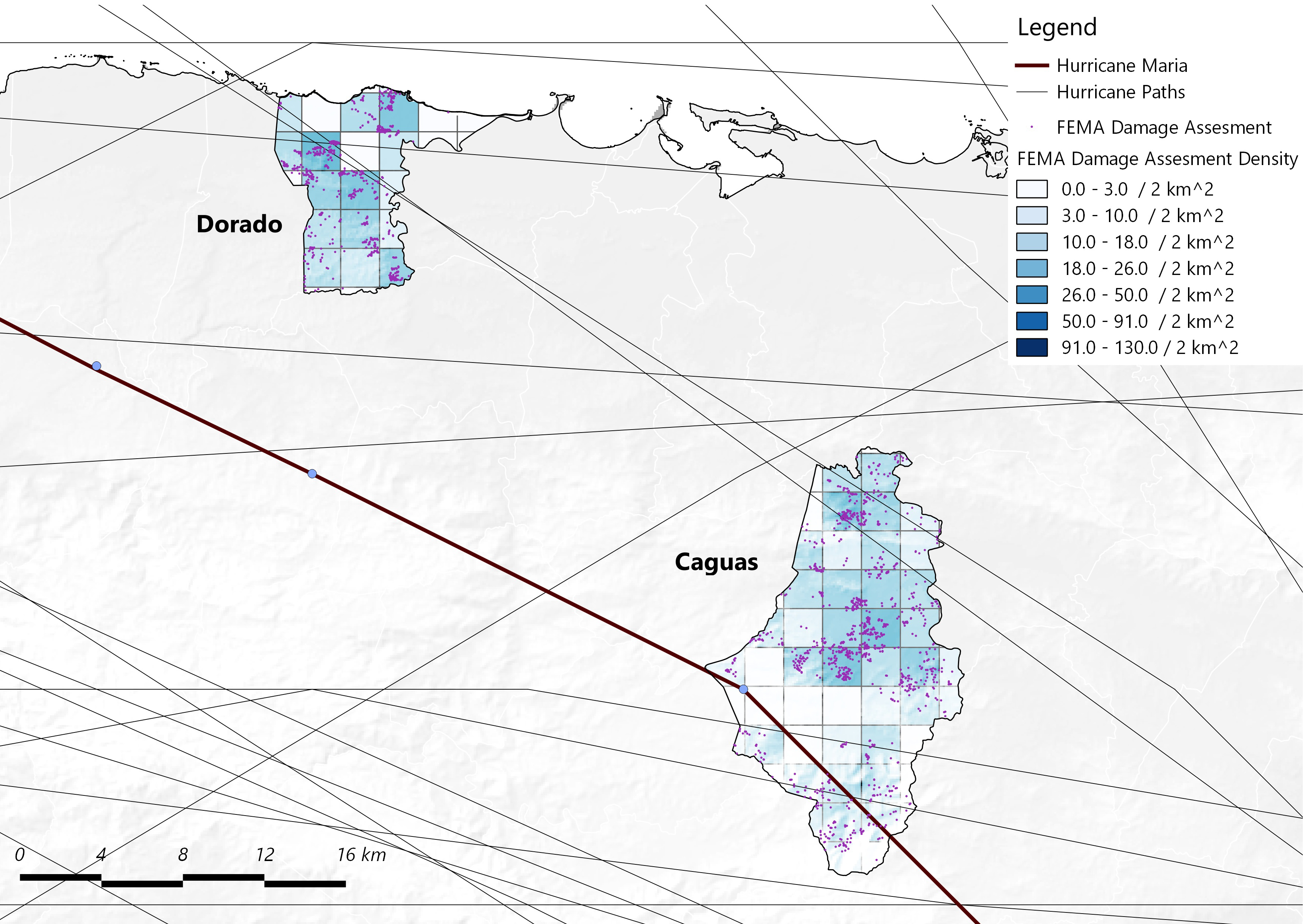
This data implies that Hurricane Maria caused more damage in Caguas, which might lead to the municipality’s decrease in property values on account of “vulnerability,” however other metrics lead to the opposite conclusion. While it may be true that Caguas is environmentally more susceptible to damage caused by natural disaster, Dorado seems more susceptible to damage in developed, populated regions. In Caguas, a municipality with 847 inhabitants per square kilometer in 2017, an aerial survey by FEMA recorded only 8 damaged or demolished structures per square kilometer. But in Dorado, with a population density of 617 per square kilometer, had on average 12 damaged or demolished structures per square kilometer. Additionally, Dorado has been subject to more direct hurricane hits historically than Caguas, and, being coastal, is prone to direct landfall whereas Caguas is not. It seems here that Dorado is a poorer investment for residential or commercial land use, as it runs a greater risk for infrastructural and urban damage, as well as for subsequent consequences such as displaced resident housing and support. As such, its drastic increase in property value post Hurricane Maria cannot be accounted for by these metrics.
Fueling further dubiety on the property value split is historical population and vacancy data, which suggests Dorado was more keenly experiencing the housing and debt crises than Caguas and the whole of Puerto Rico. In 2016, prior to Hurricane Maria, 15% of Dorado’s housing lay vacant. And, while its population trends have largely reflected the entire island’s, in 2012 the rate of Dorado’s population decrease took a sharp turn, surpassing Caguas’, and still rapidly decreasing today. This data is particularly confounding; as only a correlation it cannot signal if Dorado’s population fled on account of rising property values. However, it adds mystery to the question of why a municipality in such crisis would experience an additional $66,300 average increase in property value after Hurricane Maria, while the more residentially stable Caguas is experiencing property value decreases, and suffering from a substantial neglect of infrastructural recovery.
After these case studies, the disproportionate results of Hurricane Maria’s recovery - being change in both property value and infrastructural energy consumption - are even more surprising than initial analysis suggested. Why is the coastal, infrastructurally vulnerable, crisis-struck municipality being substantially invested in after such a devastating storm; while the inland municipality with a much higher population (which sustained less damage during Hurricane Maria) and more stable residential market failing to be restored to PREPA’s grid? What other metrics are those in power looking to in order to determine future planning and investment on Puerto Rico’s mainland? Does the key lie in Section 936 and Dorado’s corporate boom? Is an agricultural history more easily forgotten? Or is it simply the existence of beachfront property which makes Dorado seem more palatable to disaster capitalists, suggesting a future in tourist resorts and spas for the municipality - or even further, for Puerto Rico itself?
Whatever the grounds, it is clear that infrastructural changes post-Hurricane Maria do not correlate to geography, disaster vulnerability, or population trends within the municipalities studied. This disproportionate investment is directly affecting a large population of residents in interior Caguas negatively and may participate in the spread of social inequality across Puerto Rico as recovery continues to unfold.
References
“Abandoned & Little-Known Airfields: Eastern Puerto Rico.”
“Census Business Builder: Regional Analyst Edition - 2.5.”
“Disaster Response - Water Mission.”
“‘Exodus’ from Puerto Rico: A Visual Guide - CNN.”
Ferré-Sadurní, Luis, and Anemona Hartocollis. “Maria Strikes, and Puerto Rico Goes Dark.” The New York Times, December 22, 2017, sec. U.S.
Goodell, Jeff, and Jeff Goodell. 2018. “The Perfect Storm: How Climate Change and Wall Street Almost Killed Puerto Rico.” Rolling Stone (blog). September 12, 2018.
Hinojosa, Jennifer, and Edwin Meléndez. n.d. “The Housing Crisis in Puerto Rico and the Impact of Hurricane Maria,” 24.
“How Hurricane Maria Exposed Puerto Rico’s ‘Colonial Boom and Bust’ Urban Institute.”
“Hurricane Maria One Year Update.”, 12.
“Hurricane Maria Triggered at Least 40,000 Landslides in Puerto Rico in 2017.” 2019. The Landslide Blog (blog). February 11, 2019.
“Hurricane Maria Updates: In Puerto Rico, the Storm ‘Destroyed Us.’” The New York Times, January 20, 2018, sec. U.S.
“In the Aftermath of Hurricanes Irma and Maria, Resilience and Challenges in Puerto Rico and the U.S. Virgin Islands.” Federal Communications Commission, March 19, 2018.
“NASA Provides New Look at Puerto Rico Post-Hurricane Maria NASA.”
“Puerto Rico and Section 936: A Taxing Lesson from History” Citizens for Tax Justice.
“Puerto Rico Considers 100% Renewable Energy, But Natural Gas May Come First.” 2018. InsideClimate News.
“Rebuilding Puerto Rico’s Power Grid: The Inside Story - IEEE Spectrum.”
Solá, José O. “Colonialism, Planters, Sugarcane, and The Agrarian Economy of Caguas, Puerto Rico, Between the 1890s and 1930.” Agricultural History 85, no. 3 (2011): 349–72.
U.S. Census Bureau (2011). 2010 Census Summary.
US Department of Commerce, NOAA. “Major Hurricane Maria - September 20, 2017.”
US Department of Energy. “Hurricanes Maria Irma March 21 Event Summary,” March 21, 2018. DOE Situation Reports.